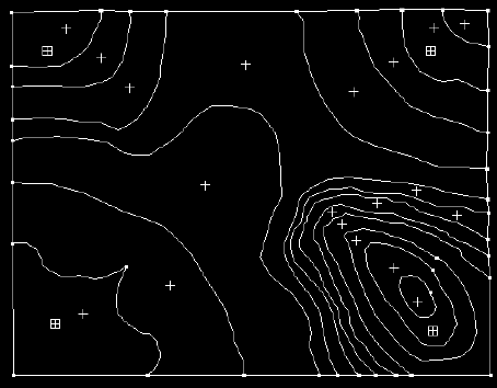

Figure 3 : Relief polygons displayed in ARCEDIT.
Now that I had the arcs of the polygons and their labels digitized, I then had to build the topology, so in ARC I typed.
Arc: build contpoly
Some messages come up which tell me that contpoly.PAT (the polygon attribute table) has been created, this is what I need. The next step was to go into INFO.
Arc: info
 INFO  EXCHANGE  CALL
12/07/1994  10:39:01
 INFO  9.42  11/11/86  52.74.63*
 COPYRIGHT 1986 HENCO SOFTWARE, INC.
 PROPRIETARY TO HENCO SOFTWARE, INC.
 US GOVT AGENCIES SEE USAGE RESTRICTIONS IN HELP FILES (HELP RESTRICTIONS)
 ENTER USER NAME>ARC

 ENTER COMMAND > ITEMS
 ENTER COMMAND >SELECT CONTPOLY.PAT
COLUMN   ITEM NAME        WIDTH OUTPUT  TYPE N.DEC
  1      AREA               4     12     F      3
  5      PERIMETER          4     12     F      3
  9      CONTPOLY#          4      5     B      -
 13      CONTPOLY-ID        4      5     B      -
Having seen the items in the contpoly coverage I created a new file into which I could enter the height data. So in INFO I used the DEFINE command to declare the items that would exist in the new file. Since I would be joining this file to the contpoly.PAT file, one of the items in the new file had to already exist in contpoly.PAT. I had written down the contpoly-id values as I entered the labels so I used this as the common item.
ENTER COMMAND > DEFINE HEIGHTPOL.DAT
ITEM NAME,WIDTH [,OUTPUT WIDTH] ,TYPE [,DECIMAL PLACES] [,PROT.LEVEL]

    1
 ITEM NAME>CONTPOLY-ID,4,5,B
ITEM NAME>
Now that I had a common item I added an item which would hold the height. The usual name for an item which holds heights in ARC-INFO is spot, so I used that. I created a 4 character wide Integer item.
ITEM NAME>SPOT,4,4,I
ITEM NAME>
I then pressed the return key to finish. I entered the polygon id of each polygon and its height using the ADD command.
ENTER COMMAND >SELECT HEIGHTPOL.DAT
0 RECORD(S) SELECTED
ENTER COMMAND > ADD

     1
CONTPOLY-ID> 1
SPOT> 0
     2
CONTPOLY-ID> 2
SPOT> 200
     3
CONTPOLY-ID> 3
SPOT> 400
And on with the rest until all the heights were entered. To finish I pressed the return key and got a message telling me the records had been added. I then entered the Q STOP command to save and leave INFO. Once in ARC I joined the data file to the contpoly.PAT file using the joinitem command. I thus created my polygon relief coverage. Subsequently I created the polygon coverage of the lakes and sea in the same way. To create the contour line vector coverage I had to approach the problem in a different way . We will see how this was handled next.

 go on .
 go back
 go home