
Arc: arcedit
Copyright (C) 1989,1990,1991,1992 Environmental Systems Research Institute, Inc.
              All Rights Reserved Worldwide.
ARCEDIT (COGO) Version 6.1.1  (December 23, 1992)
Arcedit:
First of all I had to go over the 4 TICs again on the map (just in case the map has moved ) to inform the software of the position of the map on the digitizing table , so I typed :
Arcedit: coordinate digitizer default
 Defaulting transformation coverage to /HOME/USR/SHANE/BASE
Digitize a minimum of 4 tics.
Signal end of tic input with Tic-ID = 0
Tic-ID: 1*
Tic-ID: 2*
Tic-ID: 3*
Tic-ID: 4*
Tic-ID: 0*
Scale (X,Y) = (1021.069,1728.049)  RMS Error (dig,map) = (1.778,2443.451)
I selected my base coverage, added the shrine to it and saved it as a new coverage.
Arcedit: editcoverage base
The edit coverage is now /HOME/USR/SHANE/BASE
WARNING the Map extent is not defined
Defaulting the map extent to the BND of /HOME/USR/SHANE/BASE
I wanted to add a point ( the position of the shrine ) so I needed to edit the point features of this coverage.
Arcedit: editfeature points
0 element(s) for edit feature POINTS
To enter a new point I used the add command.
Arcedit: add

--------------------Options--------------------
1) Add Label            5) Delete last label
8) Digitizing options   9) Quit
I moved the cursor to the shrine on the map and entered '1'. Then I entered '9' to finish adding points.
(Label) User-ID: 3 Coordinate = 19013.692,19850.976
1 label(s) added to /HOME/USR/SHANE/BASE
Arcedit:
To see what had been created I typed :
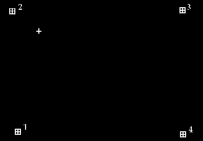
Arcedit: clear
Arcedit : drawenvironment all on
Arcedit : draw
Figure 2: The shrine digitized
At this point I saved the coverage as a new coverage shrinepoint.
Arcedit: save shrinepoint
Saving changes for /HOME/USR/SHANE/BASE
Copying /HOME/USR/SHANE/BASE to SHRINEPOINT...
Saving labels...
1 label(s) written to /HOME/USR/SHANE/SHRINEPOINT
  from the original 1 added and 0 deleted
Reopening labels...
Saving tics...
** NOTE ** Tic(s) unchanged
Reopening tics...
   BND replaced into SHRINEPOINT
Re-establishing edit feature
Arcedit:
I quit from ARCEDIT and took a look at the new coverage.
Arcedit: quit
Leaving ARCEDIT...
Arc:
I didn't intend adding any attribute data to the point coverage but I may wish to do so in the future, so I built an attribute table using the build command.
build shrinepooint
Arc: build shrinepooint point
 Building points...
Arc:
Now when I used the describe command, I saw there was one label point and that the coordinates and extents were in UTM coordinates, perfect !
Arc: describe shrinepooint
             Description of SINGLE precision coverage shrinepooint

         ARCS                              POLYGONS

Arcs          =          0            Polygons    =          0
Segments      =          0            There is NO Polygon Topology.
0    bytes of Arc Attribute Data      0    bytes of Polygon Attribute Data

         NODES                             POINTS

Nodes =          0                    Label Points =          1
0    bytes of Node Attribute Data     16   bytes of Point Attribute Data

         TOLERANCES                             SECONDARY FEATURES

Fuzzy   =            0.000 N               Tics   =               4
Dangle  =            0.000 N               Links  =               0

                             COVERAGE BOUNDARY

Xmin =                21047.424            Ymin =                20442.244
Xmax =                21047.424            Ymax =                20442.244

Continue?
                                  STATUS

The coverage has not been Edited since the last BUILD or CLEAN.

                     COORDINATE SYSTEM DESCRIPTION

Projection                  UTM
Zone                         54
Units                    METERS             Spheroid      CLARKE1866
Parameters:
Arc:
The road and river vector coverages were created in simlar fashion, except that I added arcs rather than points. However three coverages I needed to create were more complex. Two of them were polygon coverages and for these cases I needed to attach attribute data to the digitzed areas ( lakes&sea and the relief map). The third is slightly different. I needed a vector coverage of the contours in the area with the heights attached to the actual vectors. We will see how these were created in the next two sections.

 go on .
 go back
 go home