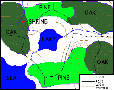

A logging company has been given a license to develop to cut down trees in the Oakwood area ( see figure 1 below). However the license has placed restrictions on where the company can cut down trees. The company will use a GIS system to devise the best place to start logging. The company also wants to calculate the total income they will generate from the logging process. They know they can get $100 income after costs for every 100 meters squared of Pine forest they strip and $200 from every 100 meters squared of Oak forest.
Figure 1: Map of the Oakwood area
The purpose of this exercise will be to select sites where the company may start logging. We will use the GIS to select these sites according to the selection rules given below. We will perform the selection using the digital data resources given on the next page.
On top of these restrictions the company also has its own selection rules.

 go on .
 go back
 go home