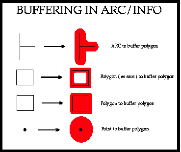

In this section we will use a common GIS method called buffering. That is we convert a vector or a point to an area see figure 8 below.
Figure 8: Buffering operations in ARC-INFO
We simply create a buffer around the roads out to a distance of 5000m the logging sites must lie within this buffer. at the arc prompt we type :
Arc:  buffer roadline roadbuf # # 5000 # line
 Buffering ...
 Sorting...
 Intersecting...
 Assembling polygons...
 Creating new labels...
 Finding inside polygons...
 Dissolving...
 Creating roadbuf.PAT...
Arc:
This creates a polygon file called ROADBUF , the area inside the polygon is the area of the map that is within 5000m of the road. Now examine the result of the buffering operation in ARCPLOT. At the ARCPLOT prompt type:
Arcplot: mapex roadbuf
Arcplot : linecolor 2
Arcplot : arcs roadline
Arcplot : linecolor 5
Arcplot arcs roadbuf
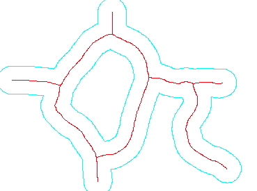
Figure 9: Road vectors and buffers

 go on .
 go back
 go home