
OK let's look at our polygon coverage of the sea and the lake. In ARCPLOT type
Arcplot: clear
Arcplot: mapex waterpoly
Arcplot: polygonshades waterpoly iswater
Arc:
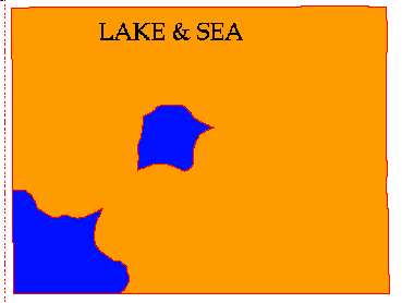
Figure 10: Polygonshades display of waterpoly
The area in brown is the land and the area in blue is the sea and lake. We want to extract the sea and lake polygons only.
First we should see what the classes are , at the ARC prompt type items waterpoly.pat
Arc: items waterpoly.pat

COLUMN    ITEM NAME    WIDTH OUTPUT TYPE N.DEC

1        AREA           4     12   F       -
5        PERIMETER      4     12   F       -
9        WATERPOLY#     4     5    B       -
13       WATERPOLY-ID   4     5    B       -
17       ISWATER        4     4    I       -
You will see an item called ISWATER, if the area is sea or lake this will be equal to 10 , if it is land then it will be equal to 1. We need to select just the areas with ISWATER = 10. We do this using the reselect command. Reselect creates a new coverage containing only selected features of an old coverage using a selection file. First we must create a selection rule file. At the ARCPLOT prompt type
Arcplot: reselect waterpoly polys ISWATER = 10
You should see :
WATERPOLY polys : 2 out of 4 selected.
Lets see what we have done in arcplot type :
Arcplot: type
Arcplot: clear
Arcplot: polygonshades waterpoly iswater
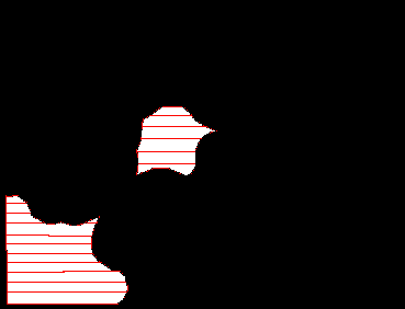
Figure 11: Waterpoly after select operation.
This time only the selected polygons ( the sea and the lake will be shown).
We now need to write the selection rule to a selection rule file we will call water.sel . At the ARCPLOT prompt type :
Arcplot:writeselect water.sel

1 selected set(s) written to water.sel
0 group by rule(s) written to water.sel
We can now extract the water polygons to a new coverage called sealake .At the ARC prompt type:
Arc: usage reselect Usage: RESELECT{in_feature_class} {selection_file} {out_feature_class} Arc: reselect waterpoly sealake polys water.sel Reselecting POLYGON features from WATERPOLY to create SEALAKE 2 features out of 4 selected. Reselecting polygons... Number of Polygons (Input,Output) = 4 3 Number of Arcs (Input,Output) = 39 7 Creating SEALAKE.pat... 7 unique nodes built for /W08/LANDUSE/GISCOURSE/SEALAKE Arc:
We now buffer the sea and lake polygons. At the ARC prompt type :
Arc:  buffer sealake waterbuff1 # # 1000 # poly
 Buffering ...
 Sorting...
 Intersecting...
 Assembling polygons...
 Creating new labels...
 Finding inside polygons...
 Dissolving...
 Creating waterbuff1.PAT...
Arc:
This creates a polygon file called waterbuff1 (see below in Figure 11b).
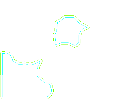
Figure 11b : Waterpoly arcs and surrounding buffers.
If you type at the arc prompt:
Arc: list waterbuff1.pat
you will see a field called INSIDE , you can see all the polygons listed , most have INSIDE = 1 ( which means they are more than 1km from any lake or the sea ) and 2 which have INSIDE = 100 ( which means they are less than 1km from any lake or the sea )

 go on .
 go back
 go home