

The logging area must be within the blue polygon (within 5km of an existing road, but not within the black polygon { it will be in white on your screen} i.e. not within 10km of the shrine and 1km of the rivers, lake or sea.
How do we map this . i.e. how do we overlay these maps ?
Answer : We use erase.
Erase extracts one polygon from another. See below in figure 12. We erase the river, sea and shrine buffer polygons from our solution area which lies inside the 5km road buffer .
Figure 12: Erase operations in ARC-INFO
Arc: usage erase

Usage: ERASE <in_cover> <erase_cover> <out_cover>
{POLY | LINE | POINT | NET | LINK | RAW} {fuzzy_tolerance}

Arc: erase roadbuff waterbuff1 sola poly
 Erasing roadbuff with waterbuff1 to create sola
 Sorting...
 Intersecting...
 Assembling polygons...
 Creating new labels...
 Creating sola.PAT...
Arc:
This create a temporary step towards our final solution called sola.
To see what we have done go to arcplot.
Arcplot: clear
Arcplot: polygonshades sola INSIDE
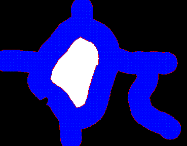
Figure 13: Roadbuffer after erase.
You can see by the blue area ( what is left of road buffer ) has pieces removed from it. The white area is not in sola, it is Outside but is painted white because it is surrounded by sola polygon - don't worry about this.
Now extract the river buffers from our current solution areas (sola).
Arc: erase sola waterbuff2 solb
 Erasing sola with waterbuff2 to create solb
 Sorting...
 Intersecting...
 Assembling polygons...
 Creating new labels...
 Creating solb.PAT...
Arc:
To see the result go to arcplot.
Arcplot: clear
Arcplot: polygonshades solb INSIDE
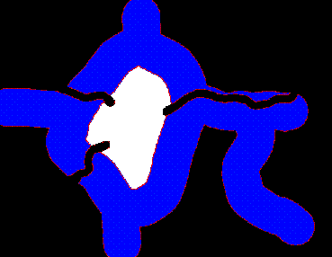
Figure 14: Roadbuffers with sea, lake and rivers buffers removed.
We can query this coverage to check that everything is OK. Remember the code for inside the solution area is 100 and outside is 1. The command in arcplot is :
Arcplot: identifym solb polys INSIDE
Enter 9 key to exit.
Click with the crosshairs on the polygon you want to examine. If you click on any blue area you should get something like:
Record  INSIDE
     5    100
{ inside the polygon }
If you click on the white area you should get :
Record  INSIDE
     5      1
{ outside the polygon }If you click on the black area you should get:
No feature located.{nothing}
Arc: erase solb shrinebuff solc
 Erasing solb with shrinebuff to create solc
 Sorting...
 Intersecting...
 Assembling polygons...
 Creating new labels...
 Creating solc.PAT...
Arc:
Once again in arcplot type :
Arcplot: clear
Arcplot: polygonshades solc INSIDE
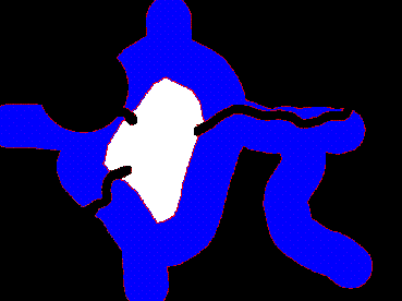
Figure 15 : polygonshades solc.
You can see another area has been cut from the top left and side of the blue region ( the area around the shrine ).
Okay that's the license restrictions dealt with, now what about the company selection procedures ?.
The first company selection rule was that the logging area must not be in a snow-bound area ( anywhere over 1000m in altitude). So let's create a coverage of the snow-bound areas and remove it from our solution so far (solc). We will do this next using our contour polygon coverage contpoly.

 go on .
 go back
 go home