

First of all examine the contour polygons to see what information is available. At the arc prompt type :
Arc: items contpoly.pat

COLUMN   ITEM NAME        WIDTH OUTPUT  TYPE N.DEC
  1      AREA               4     12     F      3
  5      PERIMETER          4     12     F      3
  9      CONTPOLY#          4      5     B      -
 13      CONTPOLY-ID        4      5     B      -
 17      SPOT               4      4     I      -
 21      SPOTCLASS          4      4     I      -
To see what is in this file we will use INFO to get some practice using the database side of the ARC-INFO GIS. At the arc prompt type :
Arc: info
 INFO  EXCHANGE  CALL
23/06/1994  15:44:02
 INFO  9.42  11/11/86  52.74.63*
 COPYRIGHT 1986 HENCO SOFTWARE, INC.
 PROPRIETARY TO HENCO SOFTWARE, INC.
 US GOVT AGENCIES SEE USAGE RESTRICTIONS IN HELP FILES (HELP RESTRICTIONS)
 ENTER USER NAME>
When using INFO, it is usual to work in capital letters so press the caps lock key after entering INFO so that this will always be the case.
The user name is always ARC so type that in and away we go.
 ENTER USER NAME>ARC
 ENTER COMMAND >
To examine the data stored in the contour polygon file we need to examine its INFO file. If the coverage had the information stored in the actual vectors ( as you might have in a road network and as we have in our vector coverage of the contour lines) then the INFO file would be COVERAGE_NAME.AAT. However this coverage is a polygon coverage therefore the INFO file will be called COVERAGE_NAME.PAT . In this case the coverage is named CONTPOLY so at the INFO prompt type :
 ENTER COMMAND >SELECT CONTPOLY.PAT
20 RECORD(S) SELECTED.

 ENTER COMMAND >ITEMS

 DATAFILE NAME: CONTPOLY.PAT       06/23/1994
    6 ITEMS: STARTING IN POSITION    1

 COL  ITEM NAME         WDTH OPUT TYP N.DEC  ALTERNATE NAME
    1  AREA                4   12  F    3
    5  PERIMETER           4   12  F    3
    9  CONTPOLY#           4    5  B    -
   13  CONTPOLY-ID         4    5  B    -
   17  SPOT                4    4  I    -
   21  SPOTCLASS           4    4  I    -
The SPOT and SPOTCLASS items look interesting - let's examine them in more detail. At the INFO prompt type:
 ENTER COMMAND >LIST SPOT,SPOTCLASS

 $RECNO   SPOT SPOTCLASS
      1      0    1
      2   1000    6
      3   1200    7
      4   1400    8
      5   1200    7
      6   1000    6
      7    800    5
      8    800    5
      9    600    4
     10    400    3
     11    800    5
     12    200    2
     13   1000    6
     14   1200    7
     15   1400    8
     16   1600    0
     17   1800    0
     18      0    1
     19   2000    9
     20   2200   10

 ENTER COMMAND >
You can see that SPOT contains the actual heights and that these have been reduced to simple classes in SPOTCLASS (we will explain why this extra class is necessary later). Now we shall look at the polygon coverage.
To get out of INFO type at the INFO prompt:
ENTER COMMAND >Q STOP
In arcplot type :
Arcplot: clear
Arcplot: polygonshades contpoly spot
Figure 15: polygonshades contpoly spot
You should see a black screen - why is this ?
The reason is that ARC-INFO is trying to look up color 1000 or color 2000 and these are all black, since it doesn't have this many colors - this is why the reduced number set SPOTCLASS is there. Try again using SPOTCLASS, at the ARCPLOT prompt type :
Arcplot: clear
Arcplot: polygonshades contpoly spot
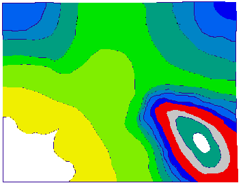
Figure 16: polygonshades contpoly spotclass
Now we can see the different contour heights .We can also query the map by typing :
Arcplot: identifym contpoly polys spot
Enter 9 key to exit.
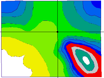
Figure 17: Querying the contour map.
Click on the map in different places with the cross-hairs, you should see something like:
Record  SPOT
    17  1800
Record  SPOT
    16  1600
Record  SPOT
     9   600
Record  SPOT
    14  1200
Press key 9 to finish { make sure the mouse is over the map when you do this i.e. the cross-hairs should be visible, otherwise nothing will happen } . We wish to extract those areas over 1000m { the snow-bound areas. Yes you've guessed it -it's reselect time again.
Arcplot: reselect contpoly polys spot >= 1000
CONTPOLY polys : 12 of 20 selected.
View the result.
Arcplot: clear
Arcplot: polygonshades contpoly spot
Arcplot: polygonshades contpoly spotclass
Arcplot:
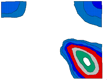
Figure 18 : Snow-bound polygons.
You can see that just the areas over 1000m are now visible. We now write this selection rule to a selection rule file. So type in arcplot:
Arcplot: writeselect height.sel
1 selected set(s) written to height.sel
0 Group-by rule(s) written to file
Arcplot:
Now in ARC extract the snow-bound polygons.
Arc: usage reselect Usage: RESELECT{in_feature_class} {selection_file}{out_feature_class} Arc: reselect contpoly over1000 polys height.sel Reselecting POLYGON features from CONTPOLY to create OVER1000 12 features out of 20 selected. Reselecting polygons... Number of Polygons (Input,Output) = 20 13 Number of Arcs (Input,Output) = 53 30 Creating OVER1000.pat... 24 unique nodes built for /W08/LANDUSE/GISCOURSE/OVER1000 Arc:
Arc: usage erase

Usage: ERASE <<n_cover> <erase_cover> <out_cover>
{POLY | LINE | POINT | NET | LINK | RAW} {fuzzy_tolerance}

Arc: erase solc over1000 sold
 Erasing solc with over1000 to create sold
 Sorting...
 Intersecting...
 Assembling polygons...
 Creating new labels...
 Creating sold.PAT...
Arc:
Go to ARCPLOT and examine the old and new solutions. First the old solution solc in red:
Arcplot: clear
Arcplot: linecolor 2
Arcplot: arcs solc
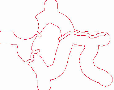
Figure 19 : Old solution.
Then the new solution sold in blue.
Arcplot: linecolor 4
Arcplot: arcs sold
Arcplot:
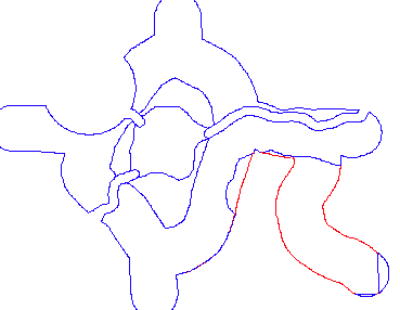
Figure 20 : New solution.
We have now further narrowed down the possible logging sites.
 go on .
 go back
 go home