

Digital elevation modeling is a powerful tool and is usually as close as most GIS get to 3-D modeling. It can be used for analysis , but is also a very powerful visualization tool. You can see a prime example of visualization using a DEM here. The last of the site selection rules states that heavy logging equipment cannot operate in any area with a slope greater than 5 degrees and thus the logging area should not contain any regions with a slope greater than this. How do we do this in ARC-INFO ?
Well the answer is we have to create a digital elevation model or DEM. In ARC these are often stored as TINs ( Triangular Irregular Network). We will see why they are called tins later. TINs hold information such as altitude, slope and aspect and we can use them to extract the areas we require.
We will use our vector coverage called contlines, so lets look at the information stored in contlines. At the ARC prompt type :
Arc: items contlines.aat{since it is a vector coverage }
COLUMN   ITEM NAME        WIDTH OUTPUT  TYPE N.DEC
    1    FNODE#             4      5     B      -
    5    TNODE#             4      5     B      -
    9    LPOLY#             4      5     B      -
   13    RPOLY#             4      5     B      -
   17    LENGTH             4     12     F      3
   21    CONTLINES#         4      5     B      -
   25    CONTLINES-ID       4      5     B      -
   29    SPOT               4      4     I      -

Arc: list contlines.aat

Record  FNODE# TNODE#  CONTLINES# CONTLINES-ID SPOT
     1      4      5	 1          4           0
     2      5      2	 2          5           0
     3      6      7	 3          7         200
     4      8      9	 4         10         400
     5     10     11 	 5         13         600
     6     12     13	 6         15         800
     7     14     15	 7         18        1000
     8     17     18	 8         23         600
     9     19     20	 9         25         800
    10     21     22	10         28        1000
    11     23     24 	11         31        1200
    12     26     27	12         36         600
    13     28     29	13         39         800
    14     30     31	14         42        1000
    15     32     33	15         45        1200
    16     34     35 	16         48        1400
    17     37     37	17         52        1600
    18     38     38	18         53        1800
    19     39     39	19         54        2000
We can see the heights are stored under the item SPOT. We will use this to create a tin called mytin. At the ARC prompt type:
Arc: createtin mytin
the CREATIN stuff comes up
Copyright (C) 1989,1990,1991,1992 Environmental Systems Research Institute, Inc. All Rights Reserved Worldwide.
CREATETIN Version 6.1.1  (December 23, 1992)
Createtin:
There are various ways of creating a tin; from a lattice , points, vectors or all of the above. We will create one using our contour lines coverage CONTLINES, so we type at the CREATETIN prompt :
Createtin: cover

Usage: COVER <in_cover> {POINT | LINE | POLY} {spot_item}
{sftype_item | sftype} {densify_interval} {logical_expression |
select_file} {weed_tolerance}

Createtin: cover contlines line spot
Createtin: end

Loading arcs from coverage contlines...
Proximal tolerance set to 0.000...
Removing points within tolerance...
Within tolerance 4. Remaining 507...
Creating TIN...
Writing TIN data structures...
Arc:
You have just created your first TIN. Time to look at what we have built.
In ARCPLOT type :
Arcplot: surface tin mytin
Arcplot: surfacedefaults
Arcplot: mapex mytin
Arcplot: tin mytin
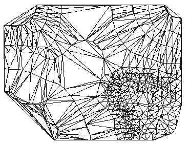
Figure 21: mytin
It is called a TIN {Triangular Irregular Network}, since it is made up of small triangles. Lets draw the original contours on top, so you can see how it is constructed. At the ARCPLOT prompt type :
Arcplot: linecolor 2
Arcplot: arcs contlines
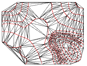
Figure 22: TIN and contour lines
You can now see how ARC-INFO creates the tin from the contours. Each side of each triangle holds the slope and aspect information. Now we shall visualize the TIN in a different and more 3-D way. We will use the ARCPLOT sufaceshade command.
Surfaceshade uses a technique whereby shadows are calculated for the 3-D landscape and drawn so that it looks similar to an aerial photograph taken late in the day and seen from above.
Arcplot: clear
Arcplot: surfaceshade
Arcplot:
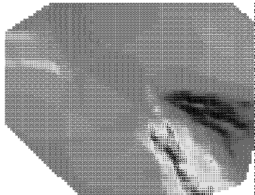
Figure 23: Surface shading of the Oakwood TIN
Arc: tinarc

Usage: TINARC <in_tin> <out_cover> {POLY | LINE | POINT | HULL}{PERCENT | DEGREE} {z_factor}

Arc: tinarc mytin slopepoly poly degree
Loading TIN data structures...
Constructing arc/polygon topology...
Arc:
OK now we have our slope map. Let us look at this new information.
Arc: items slopepoly.pat

COLUMN   ITEM NAME        WIDTH OUTPUT  TYPE N.DEC
 1       AREA               8     18     F      5
 9       PERIMETER          8     18     F      5
 17      SLOPEPOLY#         4      5     B      -
 21      SLOPEPOLY-ID       4      5     B      -
 25      DEGREE_SLOPE       4     12     F      3
 29      ASPECT             4     12     F      3
 33      SAREA              8     18     F      5

Arc:
You can see we have slope and aspect information stored here. Let's look at this in arcplot :
Arcplot: clear
Arcplot: polygonshades slopepoly degree_slope
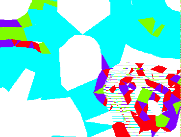
Figure 24: Slope polygon coverage.
Now try to query the slope coverage, in ARCPLOT type :
Arcplot: identifym slopepoly polys degree_slope
Enter 9 key to exit.
Click on the map in different places with the cross-hairs you should items like
Record  DEGREE_SLOPE
   991         0.000
Record  DEGREE_SLOPE
   612         1.491
Record  DEGREE_SLOPE
   506         2.266
Record  DEGREE_SLOPE
   609         0.000
Press key number 9 to finish.
Now that we have our slope information our next task is to extract the areas with a slope greater than 5 degrees and remove this from our solution.
 go on .
 go back
 go home